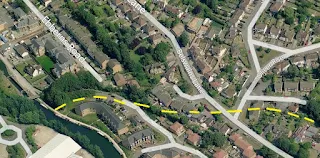
One old route was apparently abandoned through leaks and taking water away from Dickinson's Mills. From what I can make out, today's Minoan Drive and the end of Ebberns Road, used to take the old canal route; there is ONS map evidence of its continuation south westerly towards today's Belswains Lane.
I'm indebted to "Boatlife" for pointing me towards creating this comparison, who provides further explanations of locks, and guesses at where the canal went, as compared to today's landscape. http://boatlife.blogspot.co.uk/2013/04/more-of-old-route-through-apsley.html
______________________________________________
Was this the route?
Les Biggs writes, "Alan your Yellow dotted line is wrong. The start of your line by the lock was just an arm into one of Dickensons factory`s.
Without doubt the old line left by lock 65 and closely followed what is now Ebberns Road passing behind your Yellow starting point (the arm) and crossing Belswains Lane." 19/10/2015
______________________________________________
"The problems stemmed from the [Grand Junction Canal Company] diversion of the rivers Bulbourne and Gade into the canal, resulting in the loss of some of the mills’ motive power and of water for making paper pulp. In an effort to remedy the problem, the Company installed a Boulton and Watt beam engine to back-pump water from the canal below the four locks next to Nash Mills, in effect recycling water that had already flowed down through the locks. But this failed to provide a complete solution, due in part to a further problem, that of water loss through leakage in the bed of the canal in this section, which appears to have been badly constructed.
By 1812 the mills had been acquired by John Dickinson, who commenced litigation against the Company. The outcome was that the Company was required to act to prevent the loss of water referred to. Side ponds were built at the four locks in the disputed section in an attempt to reduce the water loss, but Dickinson’s complaints continued, resulting in further litigation. Telford had already been consulted by the Company on the extent of water loss in the disputed section, his opinion conflicting with that of Dickinson’s consulting engineer, and he was now engaged to survey a deviation around the problematic section of the canal, a solution that had been proposed by Dickinson himself. The survey, undertaken by Telford and W. A. Provis, resulted in a new Act (17th March, 1818) to authorise the abandonment of the existing section of the canal and the construction of a deviation. The Act stated that the route was to be along the course of the united Bulbourne and Gade, between Frogmore Swing Bridge and its junction with the tail-water of Nash Mills."
Source: http://gerald-massey.org.uk/Canal/c_chapter_05.htm#Apsley
Scene at John Dickinson's factory at Apsley on the Grand Union Canal
Black and white photograph showing the factory with the removal of the awning taking place, there is a narrowboat on the canal with officials in it doing an inspection.
Date: early-mid 20th century
 |
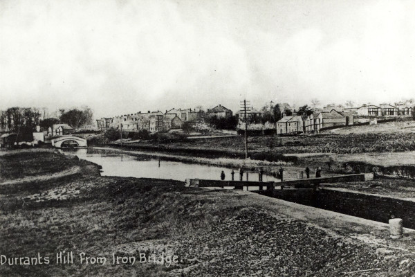
| Black and white photograph showing Durrants Hill and Apsley Lock. Contentious location. [Taken from a postcard] c1900. |
==
All credit to "Boatlife" for this old map. Original map from `The Grand Junction Canal, A. J. Faulkner
and "Boatlife's" explanations of his annotations:
A Lock 65 start of the original route.
B Lock 66 the boaters service area and the Canal Trust yard. Ebberns road runs to the rear of here.
C The point the canal crossed Belswains Lane at the junction of Olive Rise.
D Belswains Lane near to the pub, Two Tuns I think it`s called.
E Red Lion Lane. Notice how the junction E/F are in line on this old map. Check a modern map and they don`t line up. Reason is John Dickenson didn`t like Red Lion Lane running through Nash Mills so he moved it.
F The private road leading into the school grounds.
A volunteer researcher at canalrivertrust.org.uk looked into this for me and wrote in December 2015:
We have carried out some preliminary research for you.
You are probably aware that this part of the Grand Union Canal was originally built as the Grand Junction Canal, completed in 1805. It became part of the Grand Union amalgamation in 1928.
The route running via Frogmore, Apsley and Nash mills came about due to a diversion opened in 1819. The original route in that area, known as “the long pound”, was abandoned.
“The Grand Junction Canal” by Alan H. Faulkner published by David & Charles : Newton Abbot, 1972, ISBN 0 7153 5750 6 contains a plan of the original route and the diverted route and discussion of the circumstances bringing about the diversion. We have a reference copy in the archive.
We have a number of original documents in the archive:
[BW99/12/1/6] –“A Plan of the Proposed Grand Junction Canal ..…” (undated, assumed 1792) showing the parishes which the canal is proposed to pass through. This is drawn to a scale of about ¾” to 1 mile and therefore does not indicate many features of the landscape other than important roads, some villages & stately houses. This plan is approx. 1400 x 550 mm. This small scale plan was drawn before the Ordnance Survey – in some areas we have found it difficult to get a precise match with modern maps!
[BW99/12/1/4] – “References to the Plan ……….” recording names of owners and occupiers of land in each parish in each county with reference letter and number; with note of when volume lodged in office of clerk of the peace of County of Northampton (1792). For plan, see BW99/12/1/6. This is in the form of a small notebook.
[BW99/1/2/2] – Agreement with mill owners to deviate route at Apsley and Nash mills dated 1817. There is no plan attached to the document. Document less than A3 size.
[BW99/5/3/3] – Plan of Dickensons land at Apsley mill dated 1835. This shows only a small part of the new route. This is a photocopy less than A4 size.
Please note that documents in the archive are copyright. There are charges for copies of documents for private research only and then fees for using copies for publishing or commercial use. If you require copies please ask for charges and the order form and form of declaration if appropriate. (Please note that documents larger than A3 size may have to be sent to specialists for copying.)
We also allow self-service photocopying if you visit – A4 copies @ 20p per sheet, A3 copies @ 40p per sheet, again providing they are for personal research or private study only (neither of which maybe for a commercial purpose).
At present there is no charge for photographing documents using you own digital camera during a visit, again for personal research only.
See the notes below detailing charges for research.
Our main catalogue is searchable on line at http://collections.canalrivertrust.org.uk/home . “Images” refers mainly to photographs. When searching for documents (i.e. other than photographs) please un-check the box for images only.
Many of the Grand Junction Canal (and other canals) records are held by the National Archive. You may find their on-line catalogue to be helpful.


No comments:
Post a Comment